
Introduction: Why Automate Tasks with Python in ArcGIS Pro?
ArcGIS Pro is one of the most powerful Geographic Information System (GIS) tools available for spatial data analysis and visualization. While it offers a wide range of built-in tools and functionalities, many tasks within ArcGIS Pro can be time-consuming and repetitive. This is where automation comes into play, significantly improving the efficiency and consistency of workflows.
Python, a popular and versatile programming language, is integrated into ArcGIS Pro as a key tool for automation. Using Python for automation can help GIS professionals save time, reduce human error, and focus on more critical tasks. Whether you’re running complex spatial analysis, managing large datasets, or generating maps, Python can help you automate these processes and streamline your GIS work.
In this guide, we’ll walk through the steps of using Python in ArcGIS Pro for automation, from setting up Python to writing scripts and customizing your workflows. By the end of this article, you’ll have a solid understanding of how to leverage Python to automate a wide range of tasks within ArcGIS Pro.
Setting Up Python for Automation in ArcGIS Pro
Before you can start using Python for automation in ArcGIS Pro, it’s essential to ensure that everything is properly set up. Fortunately, Python is already integrated into ArcGIS Pro, so the installation process is straightforward. Here’s how to set it up:
- Install ArcGIS Pro
If you don’t already have ArcGIS Pro installed, download and install it from the Esri website. Make sure you have a valid license to use the software. - Configure Python
ArcGIS Pro comes with Python pre-installed, including the ArcPy library, which is essential for automating tasks. ArcPy is a Python site package that provides a comprehensive set of functions for working with spatial data and geoprocessing tools. - Access Python in ArcGIS Pro
To access Python within ArcGIS Pro, go to the “Analysis” tab and select “Python” from the ribbon. This will open the Python window where you can start writing and running Python code directly within the ArcGIS Pro environment. - Set Up a Python Environment
In some cases, you may want to create a custom Python environment to work on specific projects. You can use the Python Package Manager in ArcGIS Pro to create, manage, and install additional Python packages.
By following these steps, you’ll be ready to begin automating tasks within ArcGIS Pro using Python.
Exploring the ArcPy Library for Automation in ArcGIS Pro
The ArcPy library is a critical component when automating tasks in ArcGIS Pro. It provides access to over 400 geoprocessing tools and allows you to automate processes like spatial analysis, data conversion, and map creation. Below, we’ll explore some of the essential functions and methods provided by ArcPy.
- Spatial Analysis Tools
ArcPy includes a vast collection of spatial analysis tools, such as buffer, clip, intersect, and union. These tools are used for performing operations on spatial data like points, lines, and polygons. You can automate these tools to run on a series of datasets without manual intervention. - Data Management Functions
ArcPy allows you to work with geodatabases, feature classes, and tables. You can automate tasks such as creating new feature classes, adding fields, and performing queries. These functions are crucial when working with large datasets in a GIS environment. - Map Automation
In ArcGIS Pro, you can automate map creation and visualization tasks. Using ArcPy, you can add layers, adjust symbology, and export maps in various formats, which is especially useful when generating maps for reports or presentations. - Geoprocessing Services
ArcPy also allows you to create and manage geoprocessing services, making it easier to share automated workflows with others in your organization.
By understanding and mastering these tools and functions, you can perform a wide variety of GIS tasks more efficiently and accurately.
Writing Your First Python Script for ArcGIS Pro Automation
Now that we’ve set up Python and explored ArcPy, let’s dive into writing your first Python script. We’ll walk through the process of automating a simple task using Python in ArcGIS Pro.
Task: Buffer Analysis
Buffer analysis is a common spatial analysis task where you create a zone around a feature (e.g., a road, river, or point of interest). We’ll write a Python script that automates this process.
Here’s how you can write the script:
- Open the Python Window
Go to the Analysis tab in ArcGIS Pro and open the Python window. - Write the Script
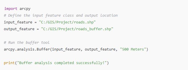
Here’s a simple Python script for buffer analysis using ArcPy:
3. Run the Script
After writing the script, press Enter to run it. This will generate a buffer around the input feature (in this case, a road shapefile) with a 500-meter radius.
By following these steps, you can automate buffer analysis using Python and ArcGIS Pro. This script can be expanded and customized for other spatial analysis tasks.
Automating Geoprocessing Tasks in ArcGIS Pro with Python
One of the most powerful capabilities of Python in ArcGIS Pro is the ability to automate geoprocessing tasks. Geoprocessing tools are at the heart of many GIS workflows, and automating them can save a significant amount of time, especially when working with large datasets or performing repetitive tasks. Python allows you to run these tools programmatically, either on a single dataset or in batch mode, enabling faster, more efficient processes.
Automating Repetitive Tasks with Python
Many GIS tasks, such as buffering, overlay analysis, and spatial joins, are often performed repeatedly across different datasets. By automating these processes with Python, you can ensure consistency, reduce human error, and significantly speed up the workflow. Here’s how to automate some common tasks:
Example: Running Buffer Analysis on Multiple Layers
Suppose you have several shapefiles of roads in a folder, and you need to create a buffer around each of them. Instead of manually running the buffer tool on each shapefile, you can automate the task with Python.
Here’s an example script that processes all shapefiles in a folder:
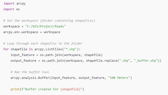
This script automatically loops through all shapefiles in the specified folder and creates a 500-meter buffer around each one. By using Python to automate this process, you can save time and ensure that every shapefile gets the same treatment without manual input.
Using Python to Run Geoprocessing Tools in Batch Mode
Batch processing is another powerful feature of Python in ArcGIS Pro. Many geoprocessing tools, such as those for raster analysis, can be run on multiple datasets at once. Batch processing allows you to execute the same tool on a series of inputs without manually adjusting the parameters for each dataset.
Here’s an example of batch processing with Python, where we’ll apply the Clip tool to a list of shapefiles:
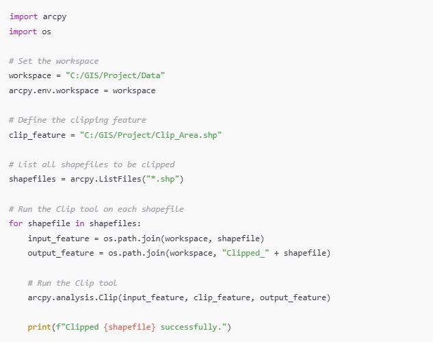
This script automates the clipping of multiple shapefiles using the same clip feature, making it easier to manage large datasets. Batch processing allows GIS professionals to perform similar tasks on many datasets in a single run.
How to Use Python to Automate Data Processing in ArcGIS Pro
Another key area where Python shines is in data processing. ArcGIS Pro offers powerful tools for working with spatial data, and Python can help automate many of these tasks, making data management faster and more efficient.
Working with Feature Classes, Shapefiles, and Tables
Python can be used to automate the management of feature classes, shapefiles, and tables within ArcGIS Pro. Whether you need to create, modify, or query data, Python provides an easy way to do it programmatically.
Example: Automating Data Extraction
Let’s say you need to extract data from multiple feature classes based on specific attributes. With Python, you can automate this task with the following script:
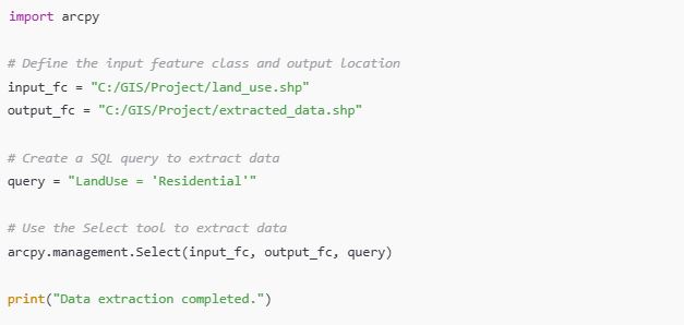
This script automates the process of extracting data based on a specific query, ensuring that the same criteria are applied to all datasets.
Automating Data Transformation
Data transformation tasks, such as converting between different formats or projections, can also be automated with Python. For instance, if you need to convert multiple shapefiles into a different projection, Python can handle this task efficiently.
Automating Data Validation and Quality Checks
Python is also useful for automating data validation and quality checks. You can write scripts to ensure that your data meets specific criteria or perform error checking before running analysis. This can save you time by identifying and fixing issues early in the process.
Scheduling Python Scripts for Automation in ArcGIS Pro
One of the greatest advantages of using Python for automation is the ability to schedule tasks to run automatically at specific intervals. This is particularly useful for tasks that need to be performed regularly, such as data updates or map exports.
Using Task Scheduler in Windows or Cron Jobs for Automation
Both Task Scheduler (Windows) and Cron (Linux/Mac) can be used to schedule Python scripts to run at predefined times or intervals. This can be especially useful when you want to automate GIS tasks without having to manually trigger them each time.
Example: Scheduling a Python Script in Task Scheduler
- Write a Python script that you want to schedule, such as updating data or generating a report.
- Open Task Scheduler and create a new task.
- In the Action section, specify the path to the Python executable and the script you want to run.
- Set the Trigger to specify when the task should run (e.g., daily, weekly).
- Save the task, and it will run automatically at the specified time.
With scheduling, you can automate recurring tasks such as daily data processing or weekly map generation without needing to manually intervene.
Customizing Tools and Workflows Using Python in ArcGIS Pro
As you gain proficiency with Python in ArcGIS Pro, you’ll want to take it a step further by customizing tools and workflows. By doing so, you can create more complex, automated processes tailored to your specific needs. Python allows you to develop custom geoprocessing tools, automate repetitive workflows, and integrate different functionalities within ArcGIS Pro.
Creating Custom Geoprocessing Tools with Python
ArcGIS Pro enables you to create custom tools that can be integrated directly into the ArcGIS Pro interface. These tools can perform a variety of tasks, from simple geospatial operations to more complex custom processes. Using Python, you can create geoprocessing tools that suit your specific automation needs.
To create a custom tool in ArcGIS Pro:
- Develop a Python Script Tool
- Start by writing a Python script that performs the task you wish to automate.
- Save your script with a
.pyextension. - Open ArcGIS Pro, and create a new toolbox or add to an existing one.
- Add the script as a tool to the toolbox.
- Define Parameters for User Input
- You can add parameters to your Python script, allowing users to input values such as feature classes or parameters for the tool directly through the ArcGIS Pro interface.
- For example, you might create a tool that asks for a buffer distance or the input feature class.
- Test the Tool
- After adding the tool to the toolbox, test it by running it with different inputs. This will ensure it works correctly and performs the desired task.
- Sharing Custom Tools
- Once your tool is ready, you can share it with other users within your organization, creating a more streamlined workflow.
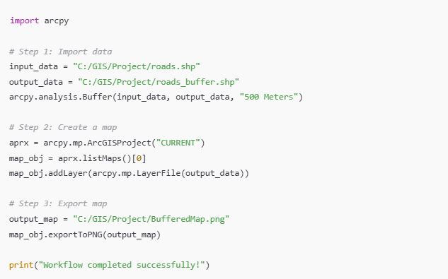
Automating Complex Workflows with Python
Sometimes, workflows in GIS can involve multiple steps and various tools. With Python, you can chain multiple processes together, automating complex workflows that would otherwise require manual input.
For example, a typical GIS workflow might involve importing data, performing a spatial analysis, generating a map, and exporting the results. Using Python, you can automate all of these steps into one seamless process.
Here’s an example of an automated workflow that:
- Imports a shapefile,
- Performs a buffer analysis,
- Creates a map, and
- Exports the map as an image.
Troubleshooting and Debugging Python Automation Scripts
Even with the best-written scripts, you might encounter issues when automating tasks in ArcGIS Pro. It’s important to know how to troubleshoot and debug your Python scripts effectively to ensure they run as expected.
Common Issues and Solutions
- Incorrect File Paths
- When referencing files in Python scripts, ensure that the file paths are correct. A common issue is providing relative paths instead of absolute paths, or using incorrect directory separators. Always use raw strings (
r"filepath") to avoid issues with escape characters.
- When referencing files in Python scripts, ensure that the file paths are correct. A common issue is providing relative paths instead of absolute paths, or using incorrect directory separators. Always use raw strings (
- Permission Issues
- Sometimes, Python scripts may fail due to permission issues, especially when trying to access or modify files. Ensure that you have the necessary permissions to read and write to the specified directories.
- Missing Dependencies
- If your script uses additional libraries (e.g.,
numpy,pandas), make sure they are installed. Use the Python Package Manager in ArcGIS Pro to manage external dependencies.
- If your script uses additional libraries (e.g.,
- Incorrect Tool Parameters
- If a geoprocessing tool is not executing correctly, check that all required parameters are correctly specified. Many errors stem from missing or incorrect parameters.
Debugging Techniques
- Using Print Statements
- A simple but effective debugging method is to add
printstatements at various points in your script to check variable values and the flow of execution.
- A simple but effective debugging method is to add
- Using ArcGIS Pro’s Python Window
- The Python window within ArcGIS Pro provides an interactive environment where you can test small portions of your script before running the entire thing.
- Error Handling with Try-Except
- To handle errors gracefully, wrap your code in a
try-exceptblock. This allows you to catch exceptions and display more meaningful error messages.
- To handle errors gracefully, wrap your code in a
- Using ArcGIS Pro’s Geoprocessing History
- The geoprocessing history tool can also help identify issues in your workflows. By checking the tool’s history, you can see exactly what was executed and where it might have failed.
By using these debugging techniques, you can quickly identify and fix issues in your Python scripts, ensuring that your automated processes run smoothly.
Best Practices for Effective Python Automation in ArcGIS Pro
To get the most out of Python automation in ArcGIS Pro, it’s essential to follow best practices that ensure your scripts are efficient, readable, and maintainable. Here are some tips to help you write high-quality Python scripts for GIS automation:
1. Write Efficient and Readable Code
When automating tasks with Python, your goal should be to write scripts that are not only functional but also efficient and easy to read. Use clear, descriptive variable names and break your code into logical sections. This will make it easier to maintain and debug your scripts in the future.
For example, instead of using vague variable names like a or b, use meaningful names like input_shapefile or output_buffer.
2. Use Comments and Documentation
Good documentation is crucial for understanding your code, especially when it needs to be shared or reused in the future. Use comments to explain what your script is doing at each step and document the purpose of each function.
3. Optimize for Performance
When working with large datasets, performance can be an issue. Optimize your scripts by using efficient algorithms and minimizing unnecessary computations. For example, avoid reading and writing data multiple times if you don’t need to.
4. Handle Exceptions Gracefully
Always anticipate errors that might occur during script execution and handle them with appropriate error messages. This will help you identify problems quickly and allow the script to continue running even if one task fails.
5. Test on Small Datasets First
Before running your script on large datasets, always test it with smaller data to ensure that it works correctly. This will save you time and resources in case something goes wrong.
6. Modularize Your Code
For complex automation tasks, consider breaking your code into smaller, reusable functions. This makes your script easier to manage and allows you to reuse common functionality across different scripts.
Learning Resources to Master Python for ArcGIS Pro Automation
If you’re looking to expand your knowledge of Python for ArcGIS Pro automation, there are plenty of learning resources available to help you along the way.
Books
- “Python Scripting for ArcGIS Pro” by Paul A. Zandbergen: A comprehensive guide to using Python for geospatial analysis and automation in ArcGIS Pro.
- “Geospatial Analysis with Python” by Erik S. Weckman: Covers geospatial analysis techniques in Python, with examples specific to ArcGIS.
Online Courses
- Esri Academy: Esri offers various courses on Python scripting and automation in ArcGIS Pro. These courses range from beginner to advanced levels.
- Udemy: Look for Python for GIS courses that focus on automating tasks with ArcGIS Pro.
Communities and Forums
- Stack Overflow: A popular platform for Python and GIS-related questions.
- GeoNet (Esri Community): A community where ArcGIS Pro users share their experiences and solutions to common problems.
Tutorials and Blogs
- Esri Documentation: Esri’s official documentation includes a wealth of examples on using Python with ArcGIS Pro.
- GISGeography: Offers helpful tutorials on Python and automation within the ArcGIS environment.
By using these resources, you can continue to expand your Python and ArcGIS Pro skills, enabling you to automate even more complex workflows in the future.
Conclusion: Achieving Efficient Automation with Python in ArcGIS Pro
Automating tasks with Python in ArcGIS Pro is a game-changer for GIS professionals. Whether you’re running repetitive geospatial analyses, processing large datasets, or generating maps, Python allows you to streamline your workflows, reduce manual effort, and ensure consistency.
By following the steps and best practices outlined in this article, you can begin automating your tasks with Python in ArcGIS Pro and unlock the full potential of GIS automation. With continued practice and exploration, you’ll become more proficient in writing Python scripts that help you save time, reduce errors, and increase the efficiency of your GIS operations.
Python is an essential tool for any GIS professional, and mastering it will give you a significant advantage in automating and optimizing your ArcGIS Pro workflows.